Publically shared files
Here you will find files that visitors have converted and also made public for you to view the flight.
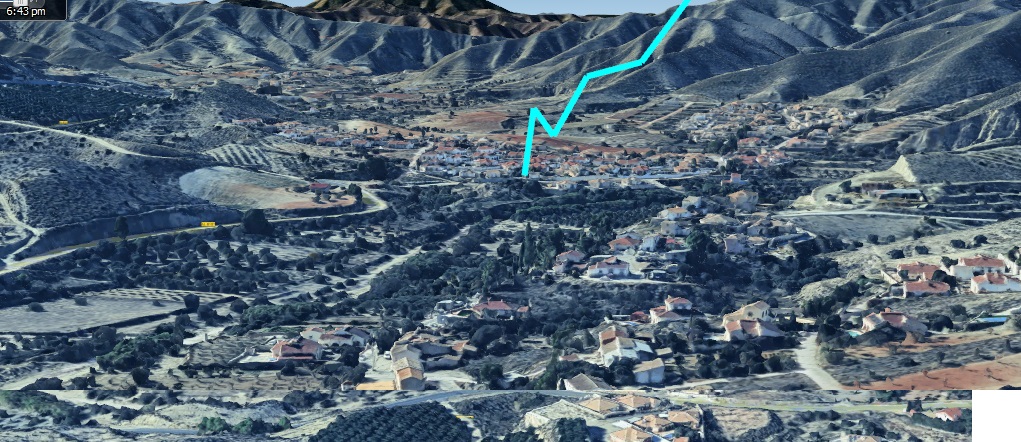
Recorded in Arboleas, SE Spain Shared at 16:32 11-02-2025
🌍 ROUTE FILE
🌍 VIRTUAL FLIGHT FILE
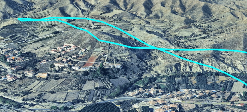
Los Carascos, SE Spain Shared at 15:04 12-02-2025
🌍 ROUTE FILE
🌍 VIRTUAL FLIGHT FILE
1/21/2025 Koh Lanta, Krabi, Thailand Shared at 03:14 15-02-2025
🌍 ROUTE FILE
🌍 VIRTUAL FLIGHT FILE
1/22/2025 Koh Lanta, Krabi, Thailand Shared at 03:30 15-02-2025
🌍 ROUTE FILE
🌍 VIRTUAL FLIGHT FILE
Benidorm Shared at 14:11 20-02-2025
🌍 ROUTE FILE
🌍 VIRTUAL FLIGHT FILE
CASTILLO DE LORCA Shared at 15:37 23-02-2025
🌍 ROUTE FILE
🌍 VIRTUAL FLIGHT FILE
Raw aerial shoot for pre-construction pipeline to be installed in Austin, TX Shared at 05:56 24-02-2025
🌍 ROUTE FILE
🌍 VIRTUAL FLIGHT FILE
McDonough, USA Shared at 13:15 27-02-2025
🌍 ROUTE FILE
🌍 VIRTUAL FLIGHT FILE
Koln, Germany Shared at 13:33 22-03-2025
🌍 ROUTE FILE
🌍 VIRTUAL FLIGHT FILE
Collio, Italy Shared at 15:59 25-03-2025
🌍 ROUTE FILE
🌍 VIRTUAL FLIGHT FILE
Eindhoven Shared at 10:59 01-04-2025
🌍 ROUTE FILE
🌍 VIRTUAL FLIGHT FILE
Kantiang Bay Shared at 04:28 03-04-2025
🌍 ROUTE FILE
🌍 VIRTUAL FLIGHT FILE
No reference Shared at 14:00 14-04-2025
🌍 ROUTE FILE
🌍 VIRTUAL FLIGHT FILE
No reference Shared at 08:46 21-04-2025
🌍 ROUTE FILE
🌍 VIRTUAL FLIGHT FILE
No reference Shared at 17:11 29-04-2025
🌍 ROUTE FILE
🌍 VIRTUAL FLIGHT FILE
parang Shared at 18:06 03-05-2025
🌍 ROUTE FILE
🌍 VIRTUAL FLIGHT FILE
No reference Shared at 04:37 16-05-2025
🌍 ROUTE FILE
🌍 VIRTUAL FLIGHT FILE
No reference Shared at 14:14 19-05-2025
🌍 ROUTE FILE
🌍 VIRTUAL FLIGHT FILE
No reference Shared at 20:31 25-05-2025
🌍 ROUTE FILE
🌍 VIRTUAL FLIGHT FILE
Netherlands Shared at 11:54 26-05-2025
🌍 ROUTE FILE
🌍 VIRTUAL FLIGHT FILE
No reference Shared at 00:57 27-05-2025
🌍 ROUTE FILE
🌍 VIRTUAL FLIGHT FILE
No reference Shared at 09:50 30-05-2025
🌍 ROUTE FILE
🌍 VIRTUAL FLIGHT FILE
No reference Shared at 09:50 30-05-2025
🌍 ROUTE FILE
🌍 VIRTUAL FLIGHT FILE
No reference Shared at 10:53 31-05-2025
🌍 ROUTE FILE
🌍 VIRTUAL FLIGHT FILE
hvac install job in birmingham alabama Shared at 19:21 04-06-2025
🌍 ROUTE FILE
🌍 VIRTUAL FLIGHT FILE
No reference Shared at 04:31 14-06-2025
🌍 ROUTE FILE
🌍 VIRTUAL FLIGHT FILE
No reference Shared at 07:00 17-06-2025
🌍 ROUTE FILE
🌍 VIRTUAL FLIGHT FILE
No reference Shared at 01:44 18-06-2025
🌍 ROUTE FILE
🌍 VIRTUAL FLIGHT FILE
Skrýchov Shared at 08:55 08-07-2025
🌍 ROUTE FILE
🌍 VIRTUAL FLIGHT FILE
hh Shared at 22:09 15-07-2025
🌍 ROUTE FILE
🌍 VIRTUAL FLIGHT FILE
DJI 619 Shared at 08:16 17-07-2025
🌍 ROUTE FILE
🌍 VIRTUAL FLIGHT FILE
No reference Shared at 07:01 21-07-2025
🌍 ROUTE FILE
🌍 VIRTUAL FLIGHT FILE
No reference Shared at 07:23 23-07-2025
🌍 ROUTE FILE
🌍 VIRTUAL FLIGHT FILE
No reference Shared at 07:38 23-07-2025
🌍 ROUTE FILE
🌍 VIRTUAL FLIGHT FILE
OOTY over the hills Shared at 15:52 27-07-2025
🌍 ROUTE FILE
🌍 VIRTUAL FLIGHT FILE
deponija karavukovo Shared at 16:56 27-07-2025
🌍 ROUTE FILE
🌍 VIRTUAL FLIGHT FILE
Deponija Karavukovo Shared at 17:17 27-07-2025
🌍 ROUTE FILE
🌍 VIRTUAL FLIGHT FILE
copenhagen Shared at 19:43 01-08-2025
🌍 ROUTE FILE
🌍 VIRTUAL FLIGHT FILE
Sarasota Crew Shared at 22:45 03-08-2025
🌍 ROUTE FILE
🌍 VIRTUAL FLIGHT FILE
Sarasota Crew Shared at 22:52 03-08-2025
🌍 ROUTE FILE
🌍 VIRTUAL FLIGHT FILE
in the hills, we dont know where Shared at 02:38 05-08-2025
🌍 ROUTE FILE
🌍 VIRTUAL FLIGHT FILE
in the hills, we dont know where Shared at 02:41 05-08-2025
🌍 ROUTE FILE
🌍 VIRTUAL FLIGHT FILE
No reference Shared at 21:38 07-08-2025
🌍 ROUTE FILE
🌍 VIRTUAL FLIGHT FILE
No reference Shared at 15:32 08-08-2025
🌍 ROUTE FILE
🌍 VIRTUAL FLIGHT FILE
No reference Shared at 15:33 08-08-2025
🌍 ROUTE FILE
🌍 VIRTUAL FLIGHT FILE
No reference Shared at 11:48 11-08-2025
🌍 ROUTE FILE
🌍 VIRTUAL FLIGHT FILE
No reference Shared at 09:59 12-08-2025
🌍 ROUTE FILE
🌍 VIRTUAL FLIGHT FILE
test Shared at 10:25 19-08-2025
🌍 ROUTE FILE
🌍 VIRTUAL FLIGHT FILE
No reference Shared at 22:51 20-08-2025
🌍 ROUTE FILE
🌍 VIRTUAL FLIGHT FILE
No reference Shared at 07:28 22-08-2025
🌍 ROUTE FILE
🌍 VIRTUAL FLIGHT FILE
No reference Shared at 07:29 22-08-2025
🌍 ROUTE FILE
🌍 VIRTUAL FLIGHT FILE
No reference Shared at 07:30 22-08-2025
🌍 ROUTE FILE
🌍 VIRTUAL FLIGHT FILE
No reference Shared at 07:31 22-08-2025
🌍 ROUTE FILE
🌍 VIRTUAL FLIGHT FILE
No reference Shared at 07:31 22-08-2025
🌍 ROUTE FILE
🌍 VIRTUAL FLIGHT FILE
No reference Shared at 18:56 23-08-2025
🌍 ROUTE FILE
🌍 VIRTUAL FLIGHT FILE
No reference Shared at 11:47 24-08-2025
🌍 ROUTE FILE
🌍 VIRTUAL FLIGHT FILE
No reference Shared at 11:49 24-08-2025
🌍 ROUTE FILE
🌍 VIRTUAL FLIGHT FILE
No reference Shared at 11:50 24-08-2025
🌍 ROUTE FILE
🌍 VIRTUAL FLIGHT FILE
No reference Shared at 11:17 28-08-2025
🌍 ROUTE FILE
🌍 VIRTUAL FLIGHT FILE
No reference Shared at 08:52 29-08-2025
🌍 ROUTE FILE
🌍 VIRTUAL FLIGHT FILE
No reference Shared at 08:54 29-08-2025
🌍 ROUTE FILE
🌍 VIRTUAL FLIGHT FILE
No reference Shared at 18:42 29-08-2025
🌍 ROUTE FILE
🌍 VIRTUAL FLIGHT FILE
No reference Shared at 08:52 30-08-2025
🌍 ROUTE FILE
🌍 VIRTUAL FLIGHT FILE
No reference Shared at 14:58 07-09-2025
🌍 ROUTE FILE
🌍 VIRTUAL FLIGHT FILE
Vuelo en el malecón tajamar de cancún Shared at 21:22 10-09-2025
🌍 ROUTE FILE
🌍 VIRTUAL FLIGHT FILE
Mavic Pro 1A Shared at 22:56 11-09-2025
🌍 ROUTE FILE
🌍 VIRTUAL FLIGHT FILE
First_FLY Shared at 23:18 17-09-2025
🌍 ROUTE FILE
🌍 VIRTUAL FLIGHT FILE
rr Shared at 23:38 17-09-2025
🌍 ROUTE FILE
🌍 VIRTUAL FLIGHT FILE
No reference Shared at 09:11 20-09-2025
🌍 ROUTE FILE
🌍 VIRTUAL FLIGHT FILE
No reference Shared at 00:49 22-09-2025
🌍 ROUTE FILE
🌍 VIRTUAL FLIGHT FILE
No reference Shared at 00:55 22-09-2025
🌍 ROUTE FILE
🌍 VIRTUAL FLIGHT FILE
No reference Shared at 01:37 22-09-2025
🌍 ROUTE FILE
🌍 VIRTUAL FLIGHT FILE
1 Shared at 13:20 25-09-2025
🌍 ROUTE FILE
🌍 VIRTUAL FLIGHT FILE
No reference Shared at 04:04 05-10-2025
🌍 ROUTE FILE
🌍 VIRTUAL FLIGHT FILE
No reference Shared at 10:49 05-10-2025
🌍 ROUTE FILE
🌍 VIRTUAL FLIGHT FILE
test Shared at 15:26 06-10-2025
🌍 ROUTE FILE
🌍 VIRTUAL FLIGHT FILE
test Shared at 02:37 07-10-2025
🌍 ROUTE FILE
🌍 VIRTUAL FLIGHT FILE
Whitefield Banglore Shared at 20:38 09-10-2025
🌍 ROUTE FILE
🌍 VIRTUAL FLIGHT FILE
No reference Shared at 06:38 10-10-2025
🌍 ROUTE FILE
🌍 VIRTUAL FLIGHT FILE
peccioli Shared at 14:57 14-10-2025
🌍 ROUTE FILE
🌍 VIRTUAL FLIGHT FILE
No reference Shared at 20:32 16-10-2025
🌍 ROUTE FILE
🌍 VIRTUAL FLIGHT FILE
No reference Shared at 20:34 16-10-2025
🌍 ROUTE FILE
🌍 VIRTUAL FLIGHT FILE
No reference Shared at 13:08 17-10-2025
🌍 ROUTE FILE
🌍 VIRTUAL FLIGHT FILE
No reference Shared at 12:36 19-10-2025
🌍 ROUTE FILE
🌍 VIRTUAL FLIGHT FILE
oke Shared at 06:54 24-10-2025
🌍 ROUTE FILE
🌍 VIRTUAL FLIGHT FILE
ajazfpv Shared at 03:11 25-10-2025
🌍 ROUTE FILE
🌍 VIRTUAL FLIGHT FILE
djifpv Shared at 03:16 25-10-2025
🌍 ROUTE FILE
🌍 VIRTUAL FLIGHT FILE
No reference Shared at 15:05 29-10-2025
🌍 ROUTE FILE
🌍 VIRTUAL FLIGHT FILE
No reference Shared at 07:09 30-10-2025
🌍 ROUTE FILE
🌍 VIRTUAL FLIGHT FILE
No reference Shared at 08:06 01-11-2025
🌍 ROUTE FILE
🌍 VIRTUAL FLIGHT FILE
0.138 Shared at 08:47 01-11-2025
🌍 ROUTE FILE
🌍 VIRTUAL FLIGHT FILE
0143 Shared at 08:50 01-11-2025
🌍 ROUTE FILE
🌍 VIRTUAL FLIGHT FILE
0.48 Shared at 08:54 01-11-2025
🌍 ROUTE FILE
🌍 VIRTUAL FLIGHT FILE
prova Shared at 15:02 06-11-2025
🌍 ROUTE FILE
🌍 VIRTUAL FLIGHT FILE
111 Shared at 15:23 09-11-2025
🌍 ROUTE FILE
🌍 VIRTUAL FLIGHT FILE
No reference Shared at 19:39 09-11-2025
🌍 ROUTE FILE
🌍 VIRTUAL FLIGHT FILE
No reference Shared at 12:22 12-11-2025
🌍 ROUTE FILE
🌍 VIRTUAL FLIGHT FILE
No reference Shared at 11:46 13-11-2025
🌍 ROUTE FILE
🌍 VIRTUAL FLIGHT FILE
No reference Shared at 12:45 14-11-2025
🌍 ROUTE FILE
🌍 VIRTUAL FLIGHT FILE
No reference Shared at 18:09 17-11-2025
🌍 ROUTE FILE
🌍 VIRTUAL FLIGHT FILE
No reference Shared at 09:02 22-11-2025
🌍 ROUTE FILE
🌍 VIRTUAL FLIGHT FILE
No reference Shared at 09:57 24-11-2025
🌍 ROUTE FILE
🌍 VIRTUAL FLIGHT FILE
Kalyaneshwar Temple NAgpur Shared at 06:43 25-11-2025
🌍 ROUTE FILE
🌍 VIRTUAL FLIGHT FILE
No reference Shared at 13:21 26-11-2025
🌍 ROUTE FILE
🌍 VIRTUAL FLIGHT FILE
Voo Shared at 12:36 28-11-2025
🌍 ROUTE FILE
🌍 VIRTUAL FLIGHT FILE
No reference Shared at 18:40 29-11-2025
🌍 ROUTE FILE
🌍 VIRTUAL FLIGHT FILE
La Muela 041125 Shared at 13:16 04-12-2025
🌍 ROUTE FILE
🌍 VIRTUAL FLIGHT FILE
No reference Shared at 11:03 12-12-2025
🌍 ROUTE FILE
🌍 VIRTUAL FLIGHT FILE
No reference Shared at 11:04 12-12-2025
🌍 ROUTE FILE
🌍 VIRTUAL FLIGHT FILE
No reference Shared at 11:14 12-12-2025
🌍 ROUTE FILE
🌍 VIRTUAL FLIGHT FILE
No reference Shared at 02:56 20-12-2025
🌍 ROUTE FILE
🌍 VIRTUAL FLIGHT FILE
No reference Shared at 07:48 21-12-2025
🌍 ROUTE FILE
🌍 VIRTUAL FLIGHT FILE
Woody Point Margate Redcliffe Peninsula Queensland AUS Shared at 02:49 25-12-2025
🌍 ROUTE FILE
🌍 VIRTUAL FLIGHT FILE
No reference Shared at 12:17 25-12-2025
🌍 ROUTE FILE
🌍 VIRTUAL FLIGHT FILE
No reference Shared at 01:45 27-12-2025
🌍 ROUTE FILE
🌍 VIRTUAL FLIGHT FILE
No reference Shared at 08:11 27-12-2025
🌍 ROUTE FILE
🌍 VIRTUAL FLIGHT FILE
No reference Shared at 08:05 29-12-2025
🌍 ROUTE FILE
🌍 VIRTUAL FLIGHT FILE
No reference Shared at 09:17 29-12-2025
🌍 ROUTE FILE
🌍 VIRTUAL FLIGHT FILE
No reference Shared at 13:03 29-12-2025
🌍 ROUTE FILE
🌍 VIRTUAL FLIGHT FILE
No reference Shared at 16:18 30-12-2025
🌍 ROUTE FILE
🌍 VIRTUAL FLIGHT FILE
No reference Shared at 17:10 31-12-2025
🌍 ROUTE FILE
🌍 VIRTUAL FLIGHT FILE
No reference Shared at 09:56 01-01-2026
🌍 ROUTE FILE
🌍 VIRTUAL FLIGHT FILE
Test Shared at 18:34 13-01-2026
🌍 ROUTE FILE
🌍 VIRTUAL FLIGHT FILE
No reference Shared at 15:45 16-01-2026
🌍 ROUTE FILE
🌍 VIRTUAL FLIGHT FILE
No reference Shared at 13:25 18-01-2026
🌍 ROUTE FILE
🌍 VIRTUAL FLIGHT FILE
No reference Shared at 13:27 18-01-2026
🌍 ROUTE FILE
🌍 VIRTUAL FLIGHT FILE
No reference Shared at 13:40 18-01-2026
🌍 ROUTE FILE
🌍 VIRTUAL FLIGHT FILE
No reference Shared at 13:44 18-01-2026
🌍 ROUTE FILE
🌍 VIRTUAL FLIGHT FILE
20260118 Shared at 13:51 18-01-2026
🌍 ROUTE FILE
🌍 VIRTUAL FLIGHT FILE
No reference Shared at 08:46 19-01-2026
🌍 ROUTE FILE
🌍 VIRTUAL FLIGHT FILE
No reference Shared at 23:29 20-01-2026
🌍 ROUTE FILE
🌍 VIRTUAL FLIGHT FILE
No reference Shared at 08:29 24-01-2026
🌍 ROUTE FILE
🌍 VIRTUAL FLIGHT FILE
No reference Shared at 08:34 24-01-2026
🌍 ROUTE FILE
🌍 VIRTUAL FLIGHT FILE
No reference Shared at 16:08 25-01-2026
🌍 ROUTE FILE
🌍 VIRTUAL FLIGHT FILE
No reference Shared at 01:14 29-01-2026
🌍 ROUTE FILE
🌍 VIRTUAL FLIGHT FILE
Ridge Schefflera Shared at 03:02 30-01-2026
🌍 ROUTE FILE
🌍 VIRTUAL FLIGHT FILE
No reference Shared at 17:31 30-01-2026
🌍 ROUTE FILE
🌍 VIRTUAL FLIGHT FILE
No reference Shared at 17:40 30-01-2026
🌍 ROUTE FILE
🌍 VIRTUAL FLIGHT FILE
No reference Shared at 17:41 30-01-2026
🌍 ROUTE FILE
🌍 VIRTUAL FLIGHT FILE
No reference Shared at 17:42 30-01-2026
🌍 ROUTE FILE
🌍 VIRTUAL FLIGHT FILE
No reference Shared at 04:30 01-02-2026
🌍 ROUTE FILE
🌍 VIRTUAL FLIGHT FILE
No reference Shared at 04:32 01-02-2026
🌍 ROUTE FILE
🌍 VIRTUAL FLIGHT FILE
No reference Shared at 04:35 01-02-2026
🌍 ROUTE FILE
🌍 VIRTUAL FLIGHT FILE
No reference Shared at 13:53 01-02-2026
🌍 ROUTE FILE
🌍 VIRTUAL FLIGHT FILE
Isle of Wight 21 April 2024 Shared at 17:10 02-02-2026
🌍 ROUTE FILE
🌍 VIRTUAL FLIGHT FILE
1 Shared at 13:08 07-02-2026
🌍 ROUTE FILE
🌍 VIRTUAL FLIGHT FILE
Praça do Papa - Vitória - ES - Brasil Shared at 14:26 16-02-2026
🌍 ROUTE FILE
🌍 VIRTUAL FLIGHT FILE
No reference Shared at 10:38 17-02-2026
🌍 ROUTE FILE
🌍 VIRTUAL FLIGHT FILE
No reference Shared at 19:57 17-02-2026
🌍 ROUTE FILE
🌍 VIRTUAL FLIGHT FILE
Yuen Long Leisure Fly Shared at 09:45 21-02-2026
🌍 ROUTE FILE
🌍 VIRTUAL FLIGHT FILE
No reference Shared at 15:47 23-02-2026
🌍 ROUTE FILE
🌍 VIRTUAL FLIGHT FILE
No reference Shared at 15:59 24-02-2026
🌍 ROUTE FILE
🌍 VIRTUAL FLIGHT FILE
No reference Shared at 16:02 24-02-2026
🌍 ROUTE FILE
🌍 VIRTUAL FLIGHT FILE
No reference Shared at 16:04 24-02-2026
🌍 ROUTE FILE
🌍 VIRTUAL FLIGHT FILE
No reference Shared at 16:17 24-02-2026
🌍 ROUTE FILE
🌍 VIRTUAL FLIGHT FILE
No reference Shared at 16:20 24-02-2026
🌍 ROUTE FILE
🌍 VIRTUAL FLIGHT FILE
No reference Shared at 19:17 24-02-2026
🌍 ROUTE FILE
🌍 VIRTUAL FLIGHT FILE
KKKK Shared at 16:33 26-02-2026
🌍 ROUTE FILE
🌍 VIRTUAL FLIGHT FILE
No reference Shared at 17:41 26-02-2026
🌍 ROUTE FILE
🌍 VIRTUAL FLIGHT FILE
No reference Shared at 00:17 09-03-2026
🌍 ROUTE FILE
🌍 VIRTUAL FLIGHT FILE
No reference Shared at 00:25 09-03-2026
🌍 ROUTE FILE
🌍 VIRTUAL FLIGHT FILE
No reference Shared at 00:27 09-03-2026
🌍 ROUTE FILE
🌍 VIRTUAL FLIGHT FILE
a Shared at 15:24 13-03-2026
🌍 ROUTE FILE
🌍 VIRTUAL FLIGHT FILE
No reference Shared at 16:55 13-03-2026
🌍 ROUTE FILE
🌍 VIRTUAL FLIGHT FILE
No reference Shared at 16:57 13-03-2026
🌍 ROUTE FILE
🌍 VIRTUAL FLIGHT FILE
No reference Shared at 16:58 13-03-2026
🌍 ROUTE FILE
🌍 VIRTUAL FLIGHT FILE
No reference Shared at 16:59 13-03-2026
🌍 ROUTE FILE
🌍 VIRTUAL FLIGHT FILE
h Shared at 03:32 14-03-2026
🌍 ROUTE FILE
🌍 VIRTUAL FLIGHT FILE
Erste Radtour Delmestau Shared at 10:33 14-03-2026
🌍 ROUTE FILE
🌍 VIRTUAL FLIGHT FILE
No reference Shared at 00:39 15-03-2026
🌍 ROUTE FILE
🌍 VIRTUAL FLIGHT FILE
No reference Shared at 09:38 15-03-2026
🌍 ROUTE FILE
🌍 VIRTUAL FLIGHT FILE
No reference Shared at 15:34 18-03-2026
🌍 ROUTE FILE
🌍 VIRTUAL FLIGHT FILE
sd Shared at 14:30 23-03-2026
🌍 ROUTE FILE
🌍 VIRTUAL FLIGHT FILE
No reference Shared at 14:36 24-03-2026
🌍 ROUTE FILE
🌍 VIRTUAL FLIGHT FILE
No reference Shared at 16:47 24-03-2026
🌍 ROUTE FILE
🌍 VIRTUAL FLIGHT FILE
a Shared at 04:00 25-03-2026
🌍 ROUTE FILE
🌍 VIRTUAL FLIGHT FILE
a Shared at 04:07 25-03-2026
🌍 ROUTE FILE
🌍 VIRTUAL FLIGHT FILE
a Shared at 04:13 25-03-2026
🌍 ROUTE FILE
🌍 VIRTUAL FLIGHT FILE
test Shared at 07:47 27-03-2026
🌍 ROUTE FILE
🌍 VIRTUAL FLIGHT FILE
No reference Shared at 07:53 27-03-2026
🌍 ROUTE FILE
🌍 VIRTUAL FLIGHT FILE
No reference Shared at 07:55 27-03-2026
🌍 ROUTE FILE
🌍 VIRTUAL FLIGHT FILE
No reference Shared at 07:59 27-03-2026
🌍 ROUTE FILE
🌍 VIRTUAL FLIGHT FILE
No reference Shared at 08:01 27-03-2026
🌍 ROUTE FILE
🌍 VIRTUAL FLIGHT FILE
No reference Shared at 08:16 27-03-2026
🌍 ROUTE FILE
🌍 VIRTUAL FLIGHT FILE
No reference Shared at 15:25 27-03-2026
🌍 ROUTE FILE
🌍 VIRTUAL FLIGHT FILE